Kevin B. Kenny
kevin.b.kenny@gmail.com
May 28, 2021
I want to reclassify all motorway and trunk highways in New York
so that (except for corrections) trunks are the same as New York's
Arterial Class 2 surface streets, motorways belonging to Arterial Class
2 are identified as suburban=yes, and motorways belonging to Arterial Class 3
are retagged as highway=primary expressway=yes.
A number of OpenStreetMap contributors in the US have been discussing the functional highway classification in OpenStreetMap as applied to the US. This has always been a difficult issue, since each of the fifty states has its own interpretation of what constitutes a classification system. (There are Federal systems, but they primarily apply when the states are seeking Federal funding, and tend for that reason to be politically determined rather than reflecting either a highway's actual importance or its physical characteristics.) None of the classification systems maps precisely onto the UK's somewhat idiosyncratic hierarchy. Moreover, the classes as assigned mostly come from TIGER, whose assessment of highway class was also idiosyncratic and inconsistent. (The purpose of TIGER, after all, is to administer the taking of the decennial census, to to provide general-purpose map rendering, routing, or navigation.)
The group has more or less returned to first principles, recognizing
that the definition of highway=* class in the Wiki and as applied
in at least the United Kingdom is that reflects a highway's function
in the routing network. A possible exception is highway=motorway,
which is defined by physical attributes; both opposing traffic and
cross traffic must be grade-separated, with vehicles entering and leaving
the motorway only by ramps. The fact that this definition is physical
is only slightly inconsistent, because nobody sane will spend the money
to build a road to that specification without a need to handle
a huge volume of traffic. (Yes, I'm aware that there are “roads to nowhere”
where the projected traffic never materialized.)
For this reason, the top tiers of road classifications should be determined by the road's function in the network. In particular, all regionally-important population centers (a working definition in the US might be the ~600 largest cities in the nation), and virtually any town of any size (say, the ~20,000 largest cities and towns) should be served by at least a primary road.
This importance is independent of road quality and physical characteristics. Because of difficulty and expense of construction, relatively small traffic volume, or other considerations (including political perversity), a trunk road in the hinterland may be a winding two-lane road through mountains. By contrast, in a dense urban area with significant autombile commuter traffic, a secondary road might be built to motorway standards but carry chiefly intra-urban and suburban traffic.
The number of lanes, surface, speed limit, and similar characterisics of roads are more significant for rendering in an American map style, but the hierarchic position (motorway, trunk, primary, secondary …) is important for several reasons:
The 'New York State Streets' database, available (with an OSM-compatible
license) from NYS GIS, is NYS DOT's tabulation of the streets and highways
of the state. It has a large and complex data dictionary.
The fields of the greatest interest for this discussion are acc and fcc.
acc is the Arterial Classification Code. The manual states:
Arterial Classification Codes (ACCs) categorize roads according to the level of travel mobility that they provide in the road network. Mobility refers to the volume of traffic that a stretch of road carries and the length of trip that it serves. Roads at the highest level of mobility serve the greatest number of trips and the longest trips. Conversely, high-mobility roads provide the lowest level of access to property. Low-level, local roads serve that function.
This definition seems to align pretty well with the “importance to the road network” definition we see on the OSM wiki. Moreover, the manual defines this code as having the cartograpic purpose of:
which is again in keeping with the OSM hierarchy.
Arterial Classification Code is a single digit
| Code | Meaning |
|---|---|
| 1 | Continental significance, interconnects ~150 largest cities |
| 2 | Regional significance, interconnects ~600 largest cities |
| 3 | Intra-state, intra-metropolitan area, interconnects ~20,000 largest towns |
| 4 | City/county significcance, connects every town and village |
| 5 | Neighbourhood/community access. Initial route origin/destination |
| 6 | Residential and service ways, including private roads |
fcc is the Feature Class Code. This is a code that breaks down along
two axes. The first is a category:
| Code | Meaning |
|---|---|
A0 |
category unknown or unspecified (Vanishingly rare) |
A1 |
primary highway with limited access |
A2 |
primary highway without limited acccess |
A3 |
secondary and connecting highway |
A4 |
local, neighbourhood and rural road |
A5 |
vehicular trail (subcategories characterize all-vehicle/4WD-only, open/gated, seasonal/year-round) |
A6 |
road with special characteristics |
| A7' | other thoroughfare |
A6 subcategories include at-grade ramp, turning circle, roundabout, ramp to/from limited-access road, service way, and ferry (further broken out by passenger/vehicular, seasonal/year-round operation)
A7 subcategories include footway, stairway, alley, driveway, parking aisle, cycleway, snowmobile trail, and planned road
The categories reflect road quality (essentially, the traffic volume for which the road is built) and change frequently along the length of a road, so are not a functional class.
The other axis shows grade separation:
| Third digit | Meaning |
|---|---|
0 |
Separation unknown or unspecified (Vanishingly rare) |
1 |
Not separated |
2 |
Not separated, in tunnel |
3 |
Not separated, in underpass |
4 |
Not separated, with street railway |
5 |
Grade-separated |
6 |
Grade-separated, in tunnel |
7 |
Grade-separated, in underpass |
8 |
Grade-separated with rail line in median |
9 |
Seasonal access (secondary and lower roads only). |
Thus, a typical motorway segment is A15 (primary limited-access highway,
oncoming traffic grade separated, in neither tunnel nor underpass)
while a typical segment of rural road might be A41 (local road,
single carriageway).
fcc is useful only in disambiguating a few cases; acc provides the
major classification.
Motorways can be identified roughly as being roads with fcc=A10 to fcc=A18.
(As mentioned eariler, motorway is a physical characteristic rather than
a marker of network importance.)
Experimenting with this shows a map that actually offers several different tiers of motorway importance that I think will be useful for routing and rendering.
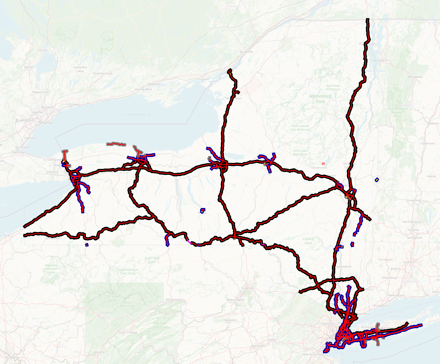
If we look at these features all taken together, at a zoom level that encompasses the entire state, we get a map that shows all the limited-access roads in the state.
There are a few islands of motorway that don't connect to the rest of
the network when rendering is restricted to motorways. Since
motorway is a physical characteristic, that can happen. There's a
stretch of US-13 through Ithaca and several stretches of the Taconic
Parkway, for instance, that are built to motorway standard, although
the grade crossings resume on either side. The Croton Expressway and
one tiny completed segment of the putative “I-99” are also in this category.
There are a few short bits where opposing traffic is not
grade-separated, with the center line in yellow rather than red. The
one near Bennington, Vermont appears to be a coding error. Chief among
the ones that appear correct are the Bayonne, Kingston-Rhinecliff,
Thousand Islands, and Peace Bridges, all of which have non-grade-separated
roadways to allow the authorities to configure different numbers of lanes
in the two directions at different times of day. (I'd propose, as an
exception, to retain the highway=motorway tag for this situation.)
This map might be all right at this zoom level, but it's quite cluttered with the suburban freeways radiating from the major cities like little balls of yarn. (There are also a couple of obvious coding errors like the little stub road, shaded pink, on Great Sacandaga Lake east of Gloversville.) It would surely be inappropriately detailed at a regional or national zoom level.
Fortunately for us, the NYSGIS file has coded things to help us. Some
of those freeways are acc=2 (shown with blue casings instead
of black), and some are even acc=3 (shown with grey casings).
For an American-styled map, I'd propose that the blue-cased ones,
which are still held to be of regional significance, should have a new
tag that distinguishes them from interurban motorways. I'd
tentatively propose to call them highway=motorway suburban=yes.
The grey-shaded ones are all short and carry local traffic almost exclusively.
They appear to be candidates for downgrade to highway=primary
with the expressway=yes tag so that they can get preferential routing and
rendering. They are not trunks, since they do not join centers of population.
If we eliminate both suburban=yes and the expressways from the
rendering, we do get a map that is suitable for rendering at a
regional zoom level. The balls of yarn around the major cities are
replaced with just a few beltways, which are indeed ones that are used
by long-haulers wishing to enter (or to avoid) the cities in question.
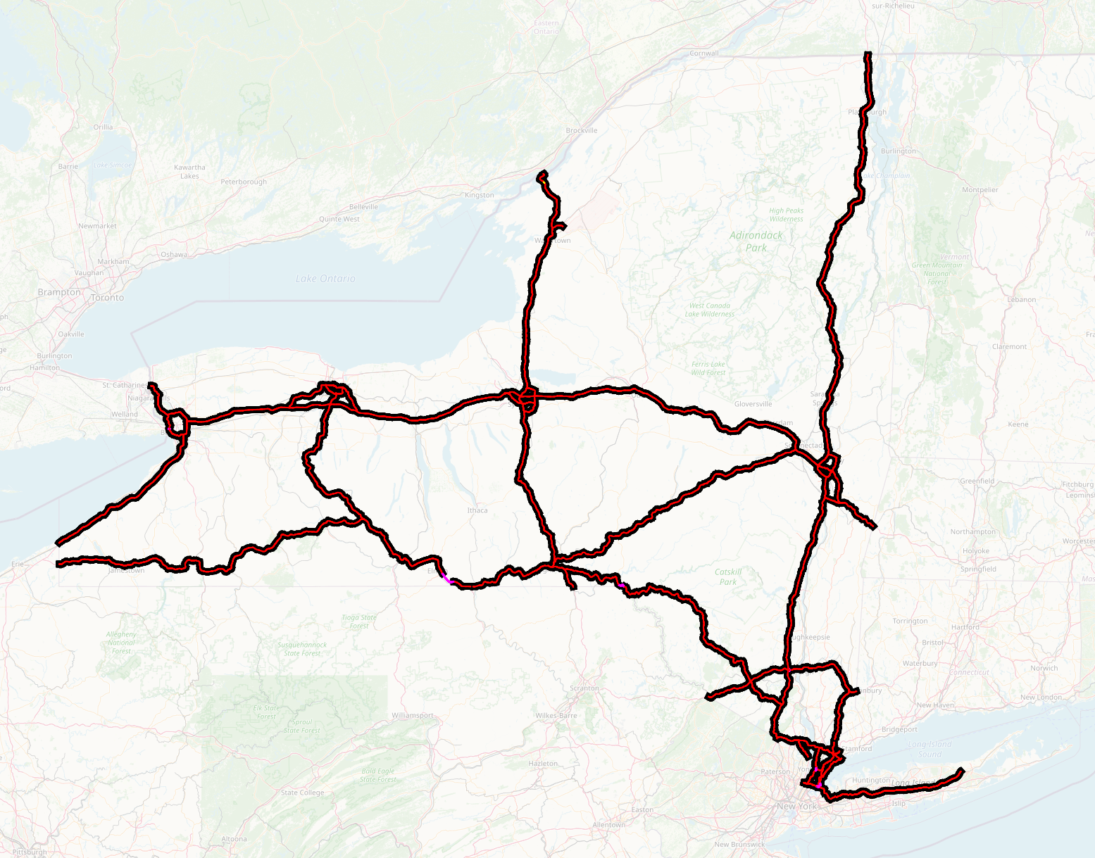
(In addition, there are a few sections, shown in purple, that are
roads of similar significance that are NOT motorways. There are two
short sections of NY-17/Future I-86 where the crossings are not
elevated, and some bits of road in The Bronx and Yonkers that serve as
links between significant motorways but also carry significant local
traffic. I'd propose that both of these cases be tagged as
highway=trunk. The unfinished motorways have at least trunk-level
routing significance. The local-street interchanges should be trunks
for their routing significance. If they are tagged as
highway=motorway_link, routers are likely to disfavor or block them
for local traffic not entering or leaving a motorway.
Arterial class acc=2 appears to map quite well indeed to the OSM
concept of 'trunk road' - the primary route between two locally
significant centers of population, whatever quality of the road. (The
US working definition of 'almost, but not quite, a freeway' maps more
closely to expressway=yes. Mapping the trunks gives close to
something that a cartographer would do to show the chief routes in the
state. In order for the rendering not to be misleading, it needs to
take into account the physical characteristics (single or dual
carriageway, number of lanes, surface) of the trunk road, rather than
rendering all trunks alike. If this is done, we get something that
begins to resemble what a cartographer might produce if asked to draw
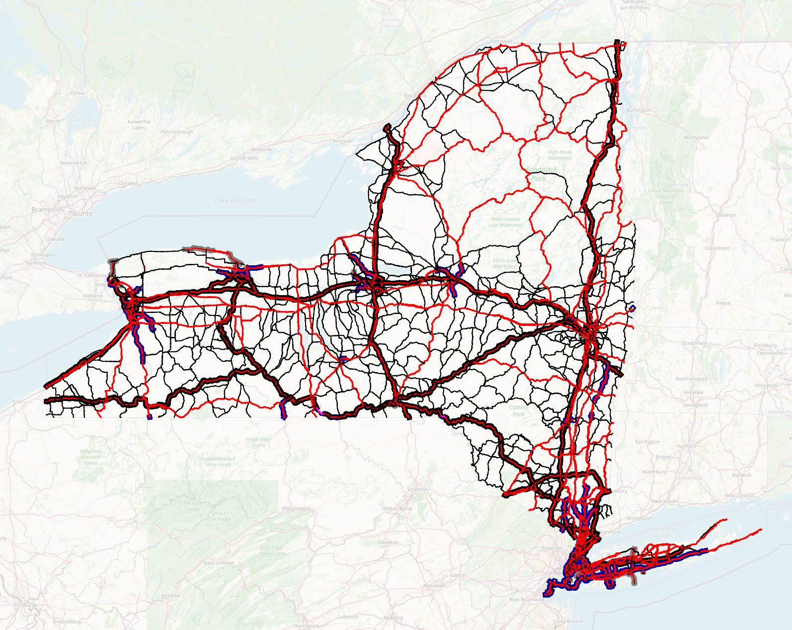
a map including the “principal roads of NY State”. The two large
blank areas in the eastern part of the state are mountain ranges, and
it's unsurprising to me that there are no trunk roads there.
The density of trunks looks fairly reasonable, and no town of any size is left unserved (The university towns of Ithaca and Potsdam have been problematic for connectivity of the road network in previous attempts at assigning classifications.). The trunk roads align well with what have already been identified as trunks in the neighbouring states to the east. US-2, US-4, VT-279, VT-9, and US-44 are precisly the trunk roads that were previously suggested as trunks joining New York and New England (in addition to Interstates 90 and 84, Merritt Parkway, and Interstate 95).
There are numerous topological glitches at this level that would have
to be hand-patched, but for the most part, they're easily identified
by following route relations. Particular examples that I noticed are
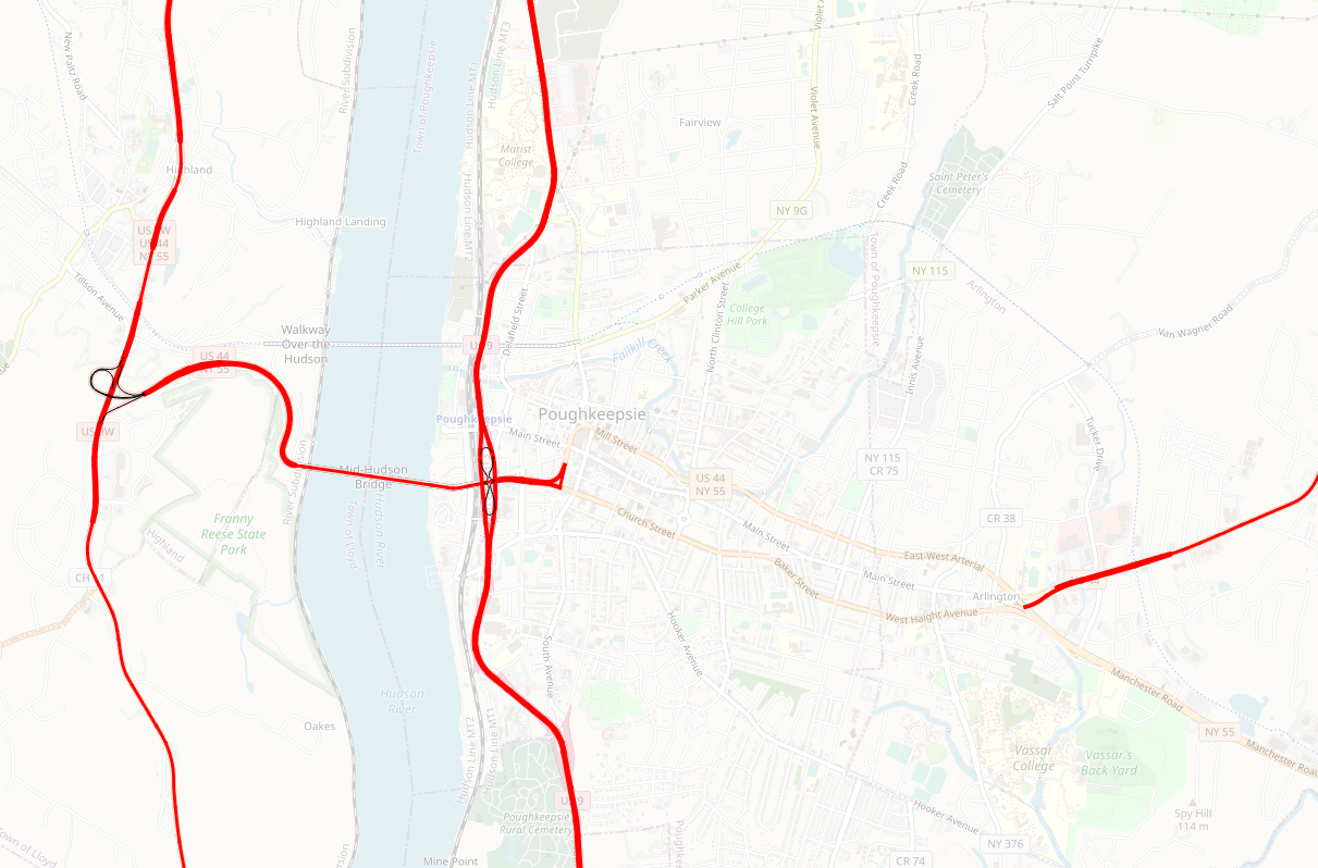
that US-44 breaks down onto a one-way pair in Poughkeepsie that is
not tagged as acc=2.
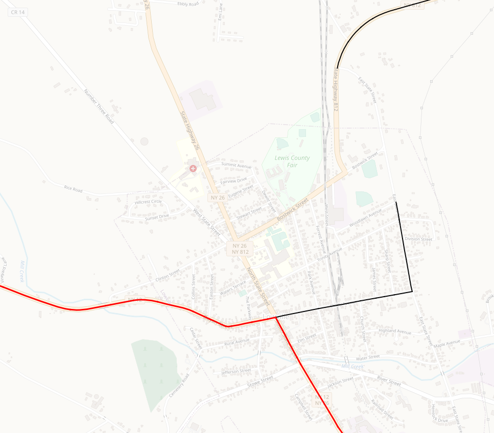
and there is a similar connectivity problem joining NY-812 with NY-12 in Lowville.
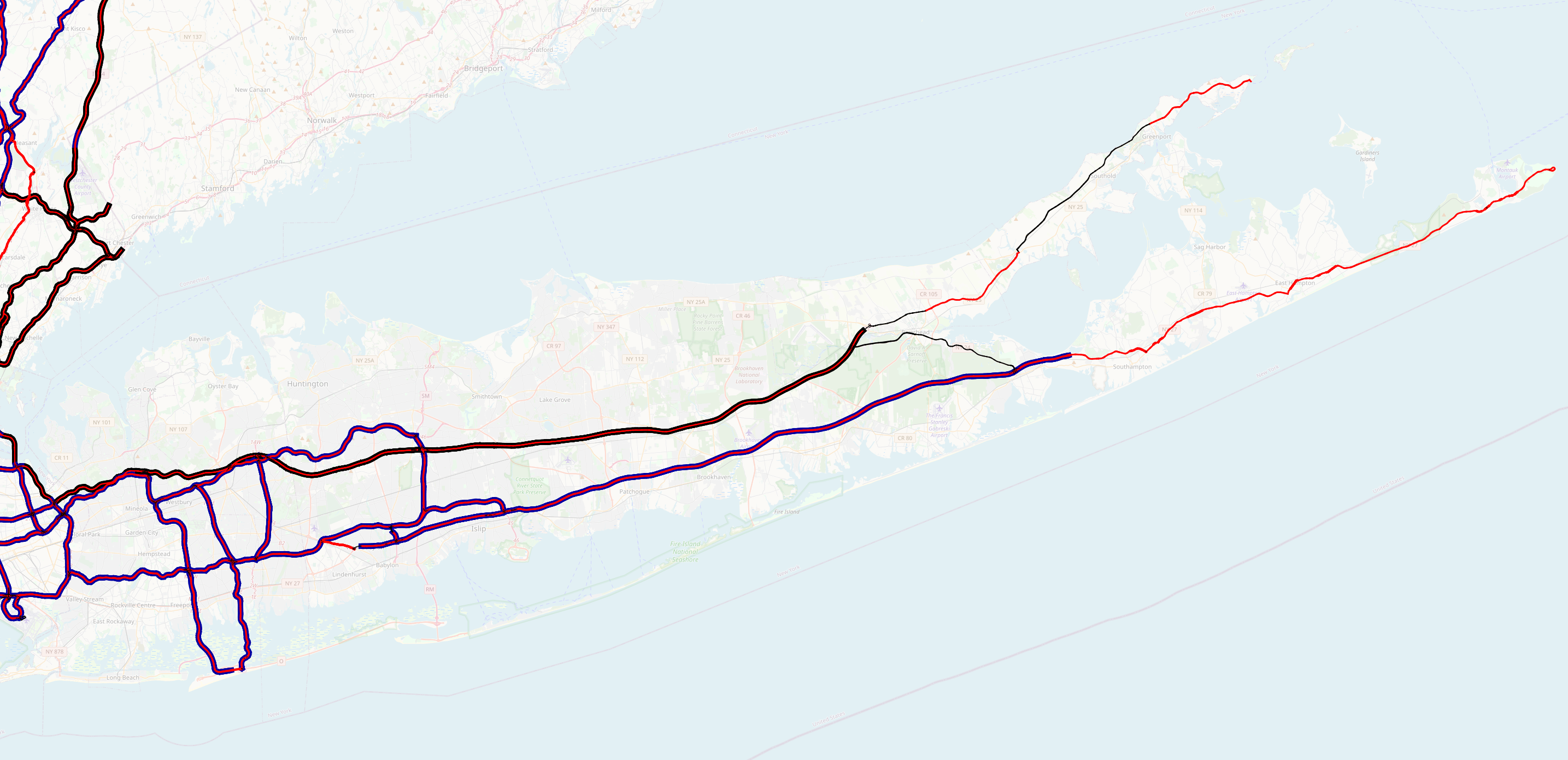
A cartographer would, of course, include the denser areas of the map as insets. New York City looks fairly reasonable. The state parkways are shown, as are the approaches to the major bridges and the two airports. (The odd bits of the Manhattan street grid that appear are precisely the ones that are needed to get to the bridges and tunnels from the local streets.) The only things that surprise me are that I might have expected to see the Ed Koch/Queensboro/59th Street Bridge (with its approaches), NY-25A, NY-25, NY-27, NY-878, and perhaps Flatbush Avenue and Beach Channel Drive, for better coverage in Brooklyn and South Queens. (With that said, however, trunks are for suburban and interurban traffic, not for traffic within the city, so perhaps the omission of these roads is justified.

Nassau and Suffolk Counties seem also to have the major parkways, plus the two highways to the North and South Forks and some connections from Southern State Parkway to the freeway portion of NY-27. Once again, the sparse coverage surprises me slightly. I might have expected to see the stub end of Northern Parkway, plus NY-454, NY-347, NY-25A east of NY-347, NY-25 east of Sunken Meadow Parkway, and one or more of the major north-south roads (maybe William Floyd Parkway). Once again, it may be that my expectation needs to be recalibrated.
I got little astonishment from what I saw in Westchester, Rockland or Orange Counties. one could argue whether particular portions of US-9, NY-100 and so on ought to be included, but in general, I think that if I were going from that part of the state to anywhere outside it, I'd wind up jumping on one of the highlighted roads, and that's practically the definition of a trunk

While the chief initial effort at road classification is directed at
rationalizing the US definition of trunk, it's still interesting
to examine how we might expand these definitions to the smaller roads.
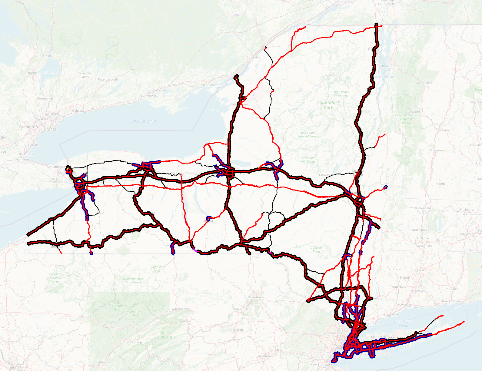
Adding acc=3 roads gives a road network that looks to have close to
the right topology and road density for primary roads. Just about any
community of any size is served by at least one, and there aren't a
lot of 'routing islands.' Of note is that the DOT has apparently done
more than a cursory assessment like 'state highway=primary'. There are
a good many county and town roads included in the promary grid, and a
good many state highways are minor enough to be omitted from it.
If the rendering is based on surface characteristics, it's obvious at
a glance that they, too, don't determine primary or trunk. Some
of the urban expressways (cased in grey) come in as primary, as do
some quite broad and fast two-lane roads (shown in red) through the
Adirondacks.
All the roads that I was surprised not to see in the New
York City suburbs reappear as primary. The urban arterials are still
missing at this level. Being a New York City native, I'm not surprised
to see Brooklyn and the Rockaways neglected in this fashion.

Unfortunately, here the process breaks down. Moving to acc=4 roads
brings in a hodgepodge, with routing islands, weird dead ends, and
incomprehensible classification decisions. This, and the lower arterial
classes, appear to be best ignored.
Instead, the best thing we can do follow some set of rules of thumb like the ones we have today. What I'd suggest:
Any numbered state highway not covered by the above, and any NY State
Reference Route: highway=secondary.
Any numbered county highway not covered by the above (note that some
county highways are also reference routes): highway=tertiary.
This includes the numbered county highways in Nassau and Westchester
counties, which are unsigned.
Other roads then need to be sorted out among unclassified, residential,
service and track. I consider that particular controversy to be out
of scope for the discussion at hand.
We could quibble endlessly about this hierarchy, but I submit that “what does the state DOT think?” (except for obvious data entry errors, and topological corrections to avoid 'routing islands') adds another authority to arbitrate our differences. I don't necessarily like all the individual classifications, but I can live with all of them. What do others think?